Laurel Highlands Trout Trail
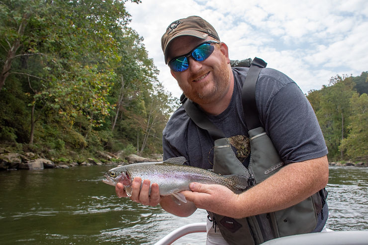
Forget Marcellus Shale, coal mining, or timbering – water is still our number one resource. And when it comes to trout streams, in particular, Pennsylvania is a gold mine. According to the brochure for the Laurel Highlands Trout Trail, of all 50 states, only Alaska has more miles of trout streams than we do. No matter where you reside in this state, chances are great that you are within a 20-minute drive of a stocked trout stream. That’s both a testament to the excellent job the PA Fish & Boat Commission does to create opportunities for trout fishermen as well as the fact that we live in such a water-rich region of the country.
The Laurel Highlands Trout Trail
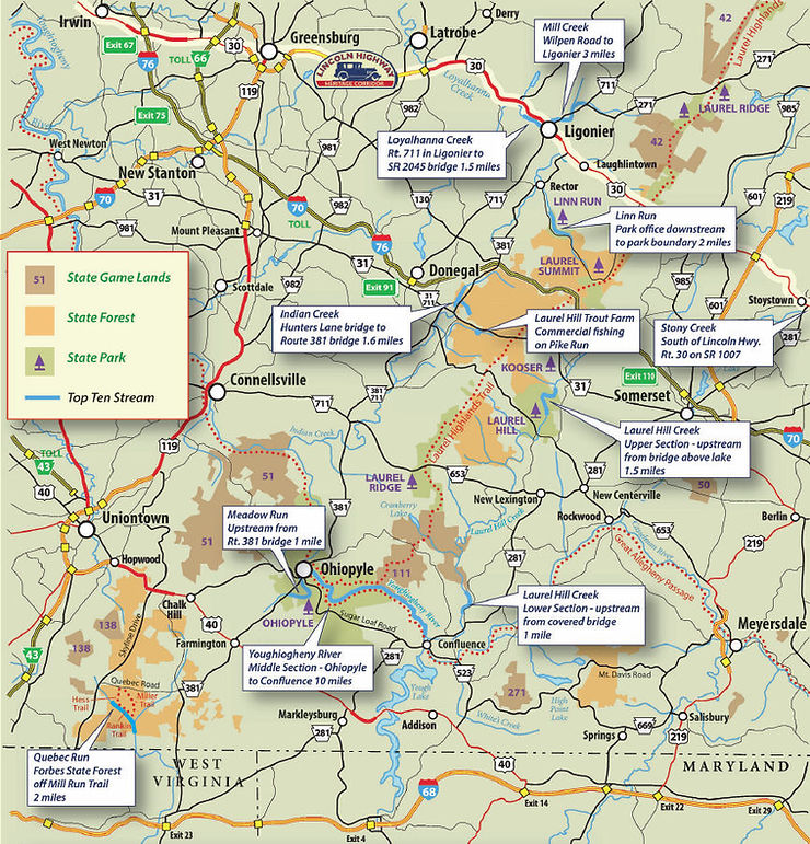
In a sense, the Laurel Highlands Trout Trail is a scenic drive for fishermen with 10 stops along a predetermined route. Each stop is a stream within the Laurel Highlands meant to show anglers the diversity and quality of the fishing opportunities in this region. In essence, it’s a complete fishing experience of what the Laurel Highlands has to offer.

Mill Creek – Fish upstream from Ligonier Valley Trail Bridge. Open to public fishing. A tributary of Loyalhanna Creek, it’s fed by exceptional value headwater streams.
Loyalhanna Creek – One of PA’s Keystone Select Stocked Trout Waters within Delayed Harvest Artificial Lures Only section. Public fishing between Route 711 bridge in Ligonier downstream to SR 2045 bridge.
Linn Run – Fish from Adams Falls picnic area upstream to Linn Run State Park Office. It has high alkalinity coldwater tributaries and is stocked. Streamside rental cottages available.
Indian Creek – Fish the Delayed Harvest Artificial Lures Only section from Hunters Bridge off Route 381 downstream 1.6 mile to the Route 381 Bridge in Jones Mills.
Pike Run – Laurel Hill Trout Farm, on Pike Run, 3 mile east of Jones Mills on the south side of Route 31. Provides fee fishing and tours of their trout hatchery. No license required.
Laurel Hill Creek, upper section – A Delayed Harvest Artificial Lures Only section in Laurel Hill State Park begins at the bridge above Laurel Hill Lake.
Laurel Hill Creek, lower section – A Delayed Harvest Artificial Lures Only section is located just off Humbert Road north of Confluence PA on PA Route 281.
Youghiogheny River, middle section – The 10 mile section between Ohiopyle and Confluence has an all-tackle Trophy Trout section beginning at the Ramcat access area.
Youghiogheny Dam – Corps of Engineers campground includes public access to an outstanding year-round tail water trout fishery.
Meadow Run – This Delayed Harvest Artificial Lures Only stretch begins where the stream crosses under Route 381 in Ohiopyle and extends upstream more than a mile. The lower area has waterfalls and slides. ADA accessible.
A Scenic Drive
While driving from one destination to the next, you will traverse both Pennsylvania’s highest mountain elevation (Mount Davis, 3,213 feet) as well as its deepest gorge (Youghiogheny River) through the heart of the Laurel Highlands. Traveling the Trout Trail presents the opportunity to learn about the history of this region while seeking out new fishing hot spots.
Of course, there are more streams to explore than just the 10 on the list. A quick stop by the Fish Commission website (www.fish.state.pa.us) provides a list of stocked streams in that area as well as the waters considered class-A wild trout, which receive no stocking. But the truth is, the streams of the Laurel Highlands are so fertile that almost every trickle, provided it doesn’t dry up during summer months, could sustain a trout population.
Launched in the spring of 2012, the Laurel Highlands Trout Trail was created by Olga Herbert of the Lincoln Highway Heritage Corridor in conjunction with Forbes Trail Chapter of Trout Unlimited. “A group of us viewed a North Carolina-based fly fishing DVD,” said Herbert. “After some discussion, we thought that the stretch from Ligonier along the Laurel Ridge down to and including the greater Ohio Pyle State Park area was just as stunning, and even more so, offered some of the best streams for fly fishing. We dubbed that 70-mile region the Laurel Highlands Trout Trail.”
Trout Fishing and More
“In addition to promoting the Trout Trail through educational programming and social events,” said Herbert, “we were also very much interested in taking action to keep the streams within the Trout Trail healthy.”
For example, in 2015, through a $1,500 grant from the Laurel Highlands Visitors Bureau, they were able to infuse 25 tons of limestone sand to the Rock Run area of Linn Run to ensure correct levels of PH and alkalinity. This helped increase the number of macro-invertebrates trout love to eat. Healthy streams produce healthy trout.
The Laurel Highlands Trout Trail does exactly what it should do – it places emphasis on Pennsylvania’s most valuable resource, its water. You can learn almost everything about a place or region just by fishing its streams and lakes. The Trout Trail offers that kind of experience for the Laurel Highlands region. The history is all there, waiting to be discovered. All you have to do is go fishing.
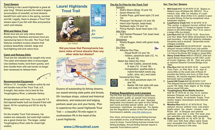
For more information about the Laurel Highlands Trout Trail, visit www.lhtrouttrail.com. Their website offers detailed descriptions and access points for all of the streams that are part of the Trout Trail. Below is the Trout Trail brochure found on their website. It should be noted that this is an old brochure and the streams on the trail have changed slightly. For instance, Quebec Run was part of the original trail, but has since been removed, while the Youghiogheny Dam has been added.
Sign up for the Dark Skies Fly Fishing e-newsletter
It's free, delivered to your inbox approximately three times each month. Your information is always kept private and used for the sole purpose of keeping you up to date on blog posts and specials in the online store.
Sign Up Now